Campuses, parks, and trails are complex.
GeoCam makes them manageable.
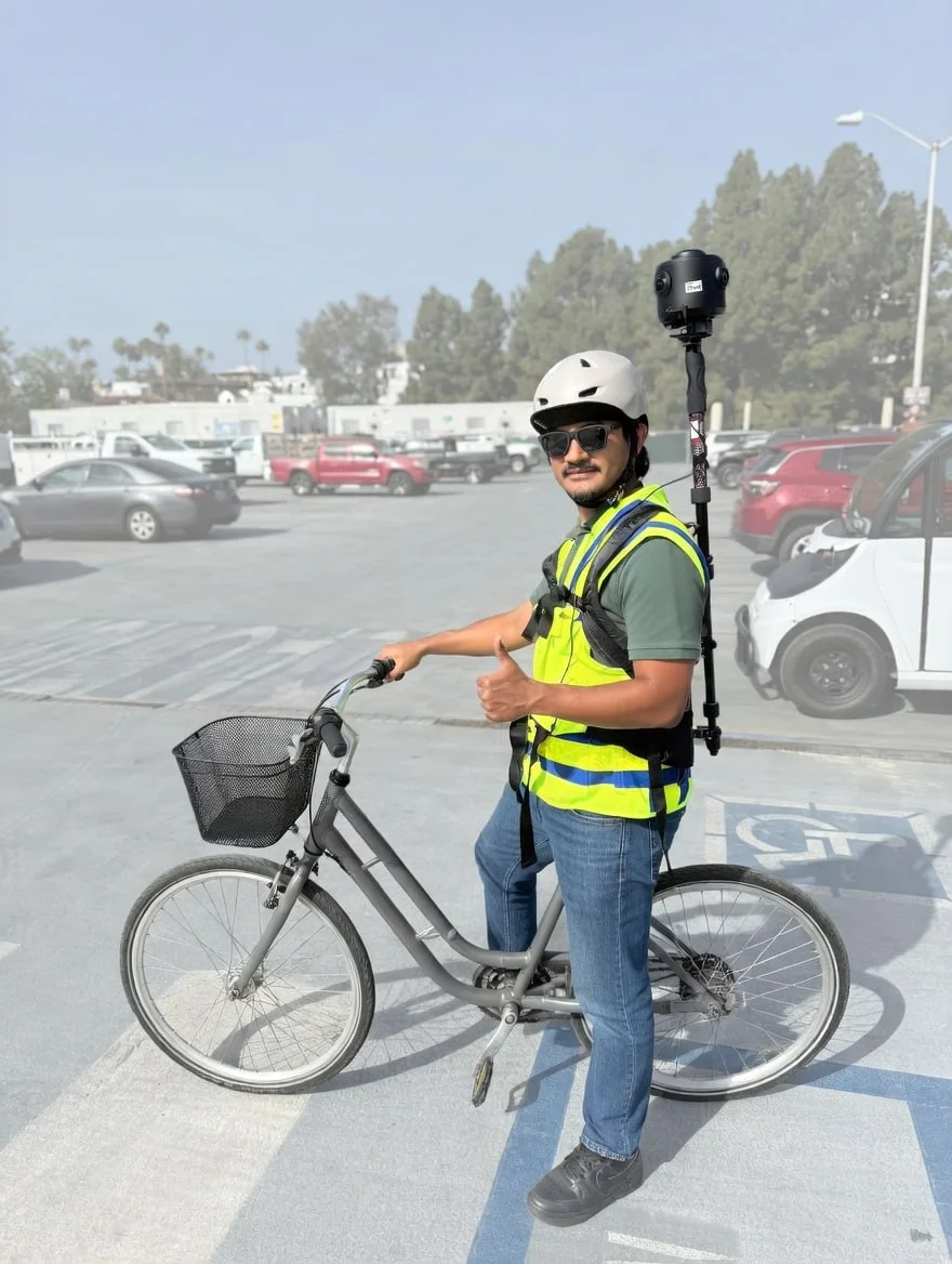
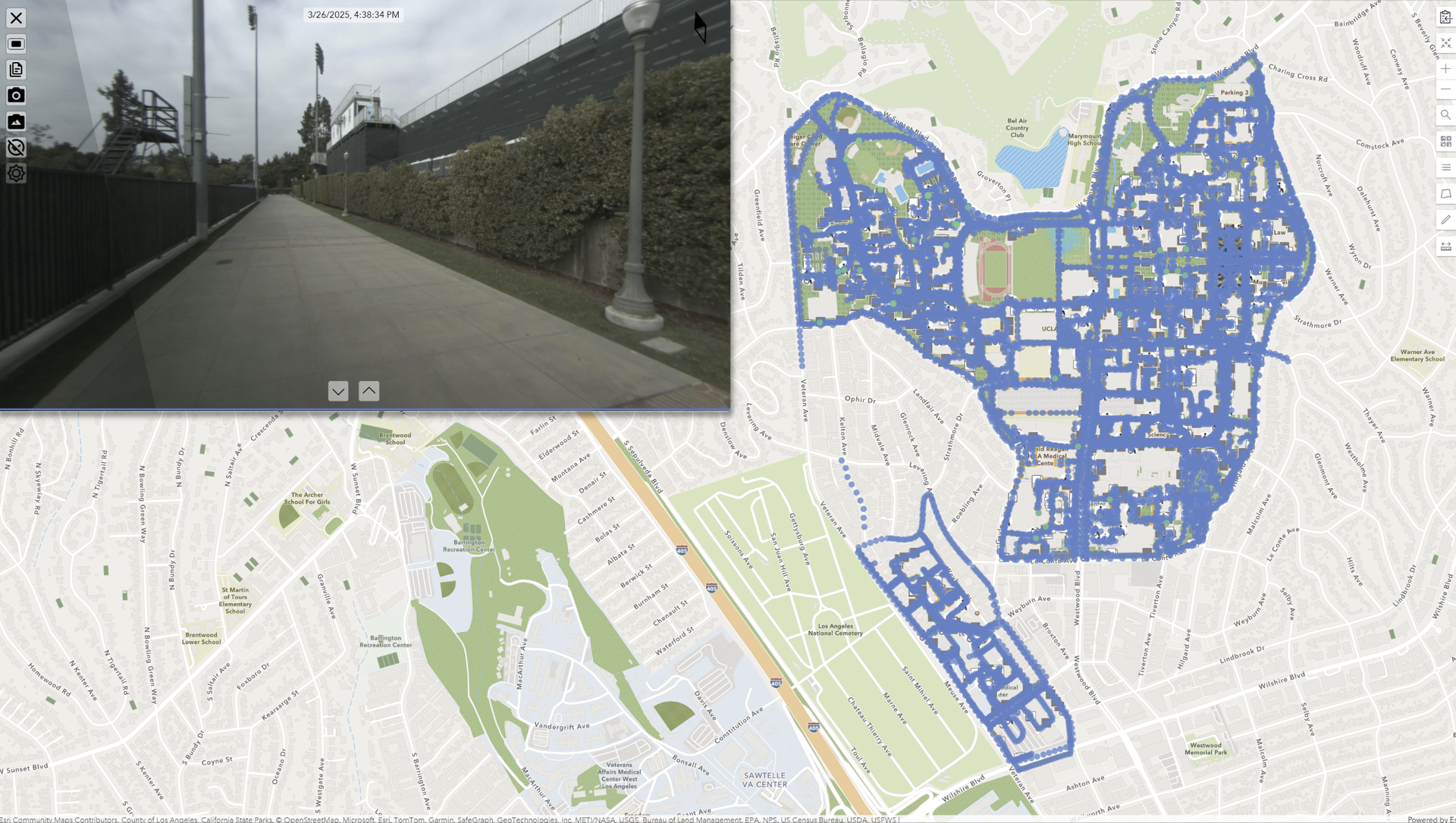
GeoCam lets your team drive roads, bike trail systems, use a cart or ATV through park facilities, walk tight outdoor areas, and go indoors. The same visual positioning workflow connects buildings, walking and biking trails, outdoor assets, and the facilities people rely on along the route.
Campus and parks documentation
can't keep up with reality
Sprawling Outdoor + Indoor Sites
Buildings, parks, fields, trails, shelters, restrooms, parking, and maintenance areas spread across multiple sites with no single source of truth.
Maps Go Stale
Trail maps, park asset lists, as-builts, and floor plans fall behind reality. New amenities, repairs, and seasonal changes are hard to keep current.
Operations Move Fast
Trail repairs, park upgrades, events, closures, and facility changes keep shifting the environment faster than documentation can keep up.
A living digital twin
of your campus, parks, and trails
Capture Campuses, Parks, and Trails
Drive roads and parking. Bike or walk trails and pathways. Capture fields, courts, shelters, restrooms, playgrounds, community centers, and maintenance facilities.
Manage A Living Site Record
Your campus and parks data stays current. Re-capture areas after construction, trail work, or facility upgrades, then keep that record available for every team.
Connect Trail Facilities To The Map
Link walking and biking trails to trailheads, signs, bridges, lighting, restrooms, shelters, fields, courts, and the facilities people rely on along the route.
Ready For GIS, Wayfinding, And Planning
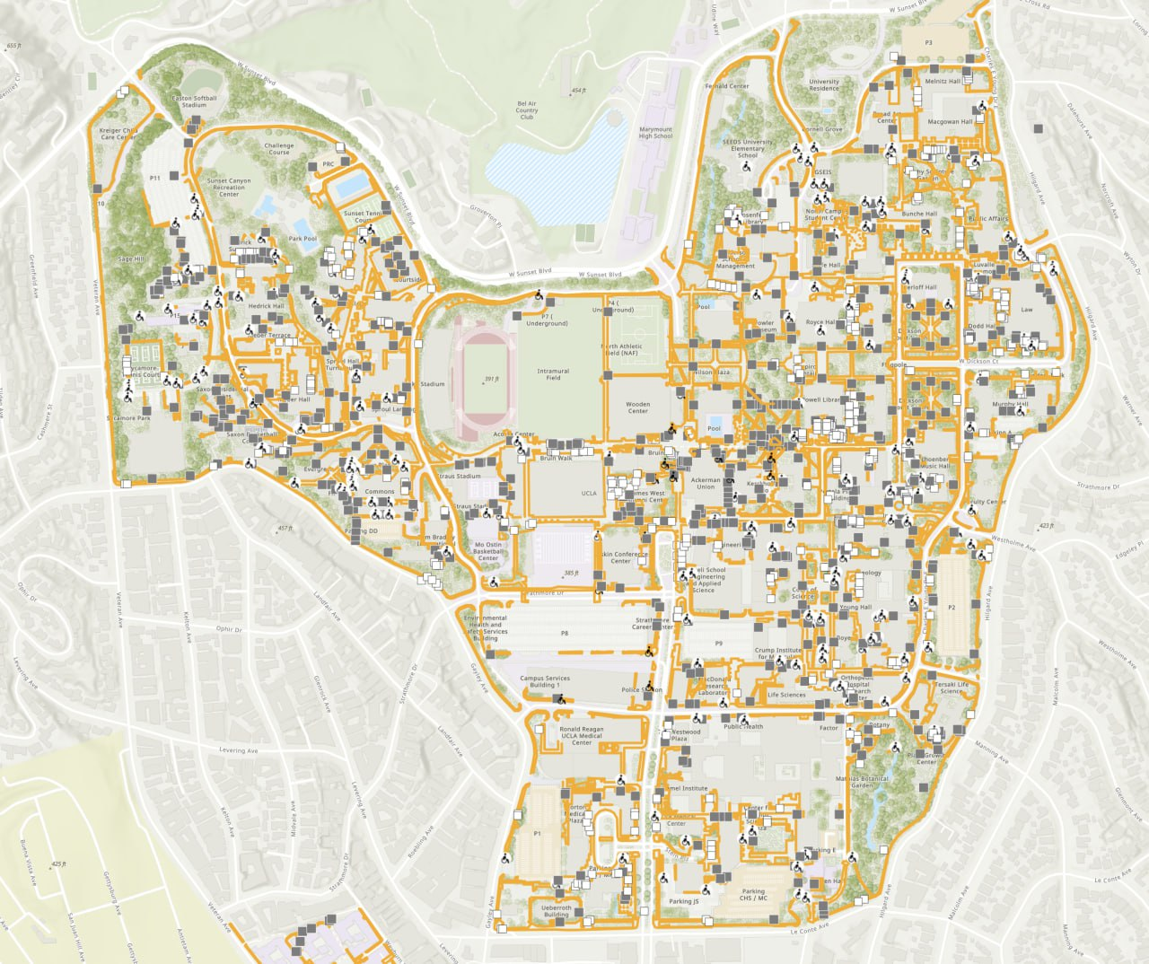
Support ADA route documentation, trail and park wayfinding, emergency access planning, facility planning, visitor maps, and virtual tours. One capture, many applications.
Campus and recreation environments of all types
Universities & Colleges
Multi-building campuses, residence halls, athletic facilities, research buildings, historic structures, and campus trails.
K-12 Districts
School sites, playgrounds, athletic fields, administrative buildings, bus facilities, paths, and outdoor gathering areas.
Corporate Campuses
Headquarters complexes, R&D facilities, manufacturing sites, parking structures, outdoor spaces, and employee paths.
Parks & Recreation
Parks, trail networks, sports complexes, recreation centers, playgrounds, shelters, restrooms, and maintenance facilities.
Capture every park, trail, facility, and field.
Capture parks by walking, cart, truck, or bike — with longer-reach mounts for larger areas. GeoCam creates and refreshes a GIS-ready visual asset inventory across every park, trail, facility, and field.
The data flows into ArcGIS and asset systems so teams can plan maintenance, document condition, prioritize work orders, and defend budgets with spatial evidence.
Why it matters
Most parks teams do not have a complete, current, photo-backed asset inventory. They know the obvious assets, but not condition, exact location, ADA issues, deferred maintenance, or lifecycle evidence. GeoCam turns a park into a measurable, repeatable, 4D asset record.
Park Amenities
Trash cans, benches, picnic tables, BBQs, kiosks, restrooms, drinking fountains, and other public-facing assets.
Playgrounds
Playgrounds, play equipment, surfacing condition, fall zones, damage, access points, and lifecycle evidence.
Trails + ADA
Trails, sidewalks, ADA ramps, curb ramps, crossings, route conditions, access gaps, and repair needs.
Sports + Lighting
Sports fields, courts, lights, fences, gates, seating, edge conditions, and field support assets.
Irrigation
Irrigation heads, valves, backflow devices, controllers, visible leaks, coverage issues, and maintenance context.
Trees + Signs
Trees, signs, trail markers, wayfinding, regulatory signage, interpretive signs, and location-backed photos.
Parking + Pavement
Parking lots, pavement cracks, striping, bollards, curbs, drainage edges, and surface condition.
Structures + Drainage
Retaining walls, drainage, culverts, erosion areas, slopes, bridges, and visible infrastructure issues.
Issues + Hazards
Graffiti, damage, hazards, encroachments, blocked access, deferred maintenance, and field-observed risk.
One capture, many applications
Walking & Biking Trails
Trail corridors, surfaces, access points, mile markers, and route conditions documented.
Trail Facilities
Trailheads, restrooms, shelters, signage, bridges, lighting, benches, and water stations.
Parks & Fields
Athletic fields, courts, playgrounds, seating, parking, amenities, and outdoor assets.
Buildings & Rooms
Recreation centers, offices, maintenance buildings, indoor rooms, and major systems.
Safety & Access
ADA routes, emergency access, evacuation context, closures, lighting, and maintenance notes.
Start with a sprint. Scale across campuses, parks, and trails.
We ship you a camera for a week. Bike or walk trails, grounds, and facilities. We deliver building, park asset, trail, and wayfinding data ready for your systems.
Common Questions
How long does it take to capture a campus or parks system?
Depends on size and scope. A small college campus or a group of parks and trails can often be piloted in 1-2 weeks. We can scale capture teams for larger universities, recreation systems, or tighter timelines.
Can we capture walking and biking trails?
Yes. GeoCam supports drive mode for roads and parking, bike or cart capture for trails and park paths, walk mode for tight areas, and indoor walk mode for building interiors. All data links together in one platform.
Can we document facilities located on or near trails?
Yes. Trailheads, shelters, restrooms, bridges, signs, lighting, water stations, parking, and nearby recreation buildings can all be captured as part of the same site record.
How do we keep data current after repairs or upgrades?
Re-capture specific areas after renovations, trail repairs, new amenities, or park upgrades. Change detection highlights differences, so your digital twin evolves with your physical sites.
Can visitors use this for wayfinding or virtual tours?
Yes. Generate shareable links for self-guided campus, park, facility, and trail exploration. It is useful for admissions, orientation, accessibility planning, and visitor-facing recreation maps.
How do we get started?
Start with a 1-week sprint. Pilot a section of campus, a park, a trail corridor, or a recreation facility to validate the workflow before scaling.
Your campus and parks, fully documented
and always current
From prospective student tours to emergency planning to capital projects, GeoCam gives every department a shared, accurate view of your campus, park system, trails, and facilities as they evolve.