The GeoCam Subscription: Big ROI at Your Budget
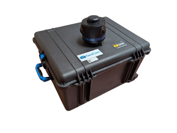
The GeoCam Hardware Kit
When it comes to street-level data capture, most organizations face a familiar dilemma. Devote a massive amount of money to purchase an expensive enterprise-scale solution or make do with outdated, inadequate data or incomplete imagery.
GeoCam believes there’s a smarter, more accessible and affordable way. That’s why the GeoCam subscription model was designed to be as powerful as it is practical. And starting at just $10,000, it’s within reach for teams and organizations of all sizes and scopes.
Whether you are part of a city planning department, a fire service, a transportation agency, or a nonprofit, GeoCam’s straightforward pricing and easy to use AI-Native Reality Capture platform provides all the tools you need to capture, organize, and act on real-world mapping data and do it rapidly.
What You Get for $10K
The GeoCam base subscription includes everything needed to launch, manage, and complete your data capture project with confidence and predictability:
The Keys - One project license covering up to 150 miles of capture or 250,000 square feet of space, ideal for small street areas, building interiors, or infrastructure.
The Kit Shipped directly to your door. The GeoCam kit includes everything you need to use the GeoCam Platform, including: the lightweight GeoCam 360° camera, versatile mounting equipment, and a pre-configured smart phone for camera control.
A Powerful Platform - A bundle of user accounts that allows customers to leverage all the features and capabilities of the GeoCam platform, including an easy-to-use editing dashboard to view, tag, and organize your imagery into a GIS-ready dataset.
Data Collection for Dummies - Onboarding support and simple training resources, so even non-technical users can start capturing and processing data immediately.
No licensing headaches. No additional equipment required. Just the tools and the support you need to start collecting clean, reliable, reality capture data - fast. Once you collect your data, which you fully own, you can access it withing the GeoCam Cloud and/or with just one click you can seamlessly download all of that imagery directly into your own GIS set up.
Additionally, if you don’t think you can take on a project like this immediately don’t worry! GeoCam knows how to work closely with each of its customers to bundle together a customized services package that will allow you to get started at your own pace, whether it’s a slow walk or a super fast sprint!
Built for Small Teams & Big Projects
You don’t need a fleet of expert technicians or a large GIS department to use GeoCam. Many of our customers are small, lean teams, sometimes just a single person, who need to quickly and clearly assess their infrastructure, hazards, or assets. Because the GeoCam platform is intuitive and the hardware kit is plug-and-play, your team can become reality capture-ready in under an hour. From city engineers to utility techs to fire inspectors, anyone on your team can use GeoCam to collect the data you need to make smarter decisions, faster.
GeoCam is Perfect For…
Municipalities - mapping sidewalks, roads, utilities, signage, and stormwater infrastructure
Public safety departments - conducting wildfire risk assessments or building pre-incident plans
Universities and research labs - gathering field data or conducting campus asset surveys
Nonprofits and community groups - documenting environmental changes and housing conditions
Utility and telecom companies -mapping and inspecting poles, lines, pipelines, and substations
GeoCam works just as well inside buildings as it does on streets. That means a facility tour, campus map, or damage assessment can be done with a simple walk-through and a few clicks.
Informed Intelligence: The Power of Data
As municipalities grow, infrastructure ages, and the risks become more complex, accurate and up-to-date visual data is critical to power proper planning and informed design for public safety, budgeting, and equitable resource allocation.
With GeoCam, you are not locked into an expensive, long-term contract or forced to hire outside specialists. You’re getting real spatial intelligence in your hands quickly, affordably, and on your timeline. GeoCam is all about saving time, building smarter systematic solutions, and making your community safer and more resilient.
Simple, Scalable Subscription Solutions
If your project is larger than 150 miles or more than 250,000 square feet, GeoCam subscriptions scale easily. Whether you need additional licenses, users, or storage, expanded team access, or advanced features, we’ll tailor the subscription to meet your operational and financial needs, so you can focus on what matters: the work.