Why Fiber Engineering Teams Rely on GeoCam
High-Fidelity 3D Geospatial Data for Faster, Smarter Outside-Plant Implementation and Maintenance
The U.S. fiber market is in the middle of the fastest expansion in its history—driven by record FTTH builds, Federal funding, and the explosive growth of data center interconnects for AI and cloud. Engineering teams are under pressure to design more miles, turn around permits faster, and reduce construction surprises.
Traditional field workflows simply can’t keep up.
GeoCam gives fiber engineers a scalable, route-wide tool to create digital twins of the real world—easily captured, usable everywhere, applicable across the entire lifecycle of an project.
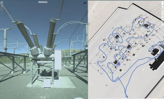
Capture When and Where you need. Design + Permit + Construction Feasibility.
GeoCam’s 360° reality-capture hardware enables you to scale up your fielding when and where you need. Need thousands of miles done fast?…. no problem just add more cameras.
Then let GeoCam’s AI-powered processing convert roads, poles, facades, terrain, and ROW conditions into accurate, measurable 3D data at a scale not achievable with other tools. Combine Drive captures with Walk Captures for 100% coverage of the network area.
Your team can then “walk the route” from the office, measure spans and clearances, and make design decisions without repeated truck rolls.
INSERT: video or picture of Costa Mesa FTTH map>
Better Pole Data. Better Make-Ready.
Pole records are often incomplete or outdated—creating the biggest bottlenecks in FTTH and aerial DCI builds.
GeoCam solves this with:
High-resolution pole imagery and geometry
Attachment identification
Clearance and violation insights
Pre-screening for replacements or rearrangements
Make-ready engineering becomes cleaner, faster, and far more defensible.
<screenshot of pole attachment measurements>
Permit Packages That Get Approved
With GeoCam, your permitting team builds from current, visual, route-wide data, producing submittals that clearly show:
Existing conditions
Proposed attachments
ROW constraints
Accurate measurements and visuals
This reduces back-and-forth with permitting authorities and accelerates approval timelines—critical in Federally Funded and hyperscale build cycles.
<get a quote from GeoSolv here>
Build FTTH and Data Center Interconnects with Confidence
From residential neighborhoods to long-haul corridors, GeoCam’s 3D data supports:
Last-mile design
Backbone & metro route studies (including competitive landscape)
Aerial vs. underground comparisons
Low-latency path design for data center interconnects
Constructability assessments before a crew is ever deployed
One platform supports both neighborhood density and hyperscale connectivity demands.
A Long-Term Digital Asset
Your GeoCam captures become a baseline for operations, enabling:
As-built verification
Change detection
Vegetation and encroachment monitoring
Maintenance and resilience planning
You get ongoing value long after the initial design work is complete.
The Bottom Line
GeoCam gives fiber engineering teams the ability to design faster, permit smarter, and build with fewer surprises—at a moment when the industry cannot afford inefficiency.
If you’re designing FTTH networks, data center interconnects, or large-scale fiber corridors, GeoCam isn’t just helpful.
It’s the new foundation for scalable fiber deployment in the U.S.