Why and How GeoCam’s Data Workflow Changes Everything
In high-volume reality capture, the quality of your work depends on one thing above all else: your data. Yet for years, the industry has relied on workflows that treat data management as an afterthought, using SD cards, manual transfers, late-night offloads, slow compression jobs, and fragile storage systems that crack the moment something goes wrong.
One lost SD card…
One corrupted drive…
One failed laptop…
And suddenly, an entire day is gone.
GeoCam was built so that never happens again.
This is what makes its data workflow different and why it changes everything for field teams, program managers, and operations leaders.

Figure 1:
View all your captures and their status (processed, uploaded, and offloaded). Green is processed, but not uploaded or offloaded.
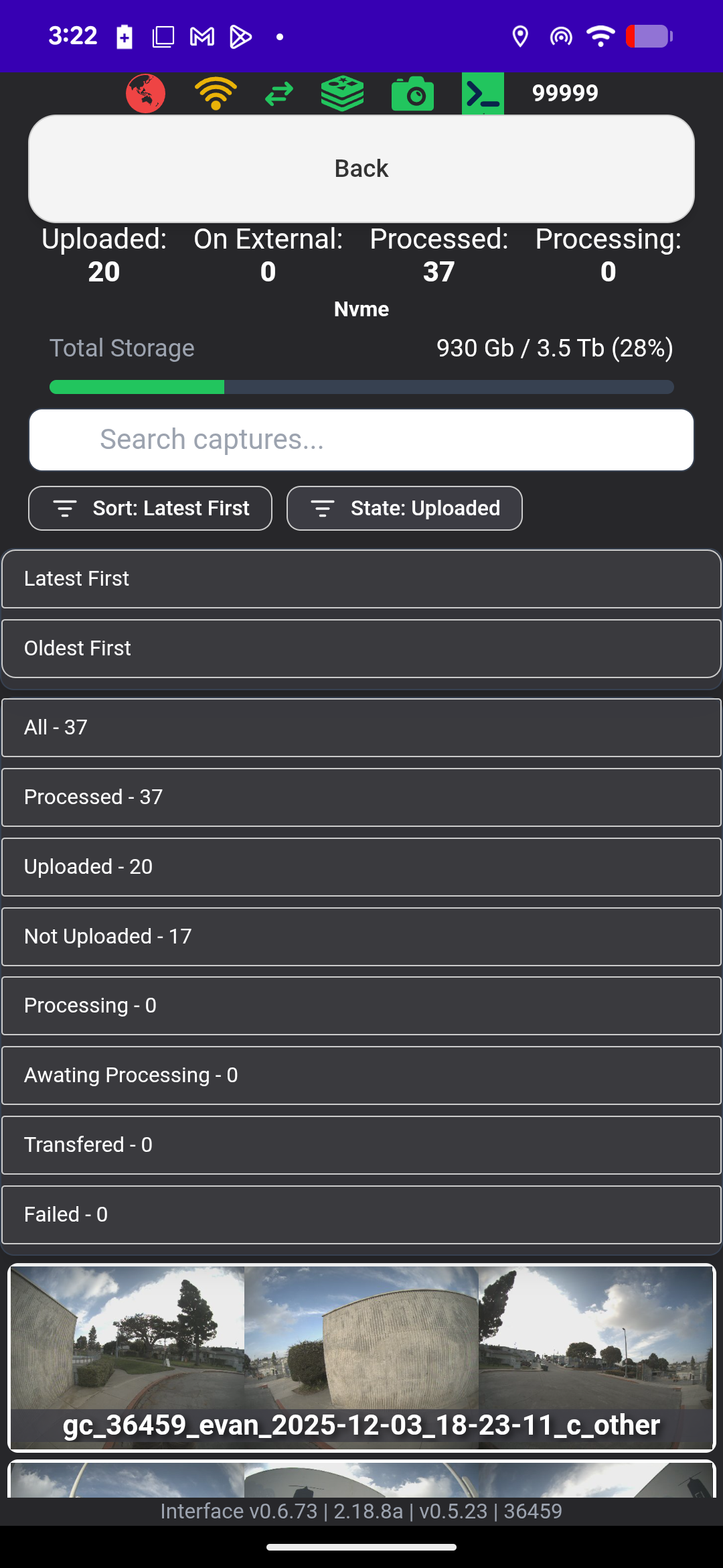
Figure 2:
Quickly filter, sort, and search your captures based their status and age.
Real-Time Compression: Integrated, Automatic, and Designed for Speed
Traditional workflows require time-consuming post-processing to compress and organize imagery. GeoCam eliminates that burden by compressing every image as it’s captured, with ratios up to 20:1.
That means:
No separate transcoding step
No babysitting compression software
No waiting to find out if your footage actually processed correctly
And the system prioritizes intelligently:
At urban speeds (~35 mph) or on foot: full-rate capture and full-rate compression
At highway speeds (~75 mph): the camera prioritizes capture, buffers compression, and catches up automatically when you slow down or stop
The result is simple: You never drop frames. You never lose data. You never stay up late waiting for files to finish.

Figure 3:
Driving or walking while using GeoCam generates a huge amount of imagery, capturing more views of the objects you need. If a 10m interval isn’t enough, you can run at 2m for driving and walking at five shots per second or roughly every 10cm!. As you drive and/or walk you can see compression status in real-time. It keeps pace with the very fastest freeway driving so you’re able to offload and upload as you drive and once you stop for a quick break it catches up. The “Pipeline” function shows you your exact status.
Continuous USB Backup: Redundancy That Travels With You
GeoCam introduces something no other camera offers: automatic, in-vehicle redundancy. Every file saved to the internal drive is simultaneously mirrored to a connected USB device, continuously, in near real time.
Why that matters:
You leave the field with TWO copies of every image
No one has to remember to press a button, swap a card, or start a transfer
If the camera falls, fails, or gets damaged at 3 p.m., the entire morning is already safe
At the end of the day, the workflow is almost laughably easy:
Park → Pull the USB → Hand it off or plug it in → You’re done!
No more offload marathons. No more “we’ll check when the crew gets home.” Just capture, pull, upload.
Upload From the Field: Even in Disaster Zones
Connectivity is never guaranteed, and GeoCam treats that as a feature, not a flaw. Its cloud sync is built for real-world operations:
Metadata uploads continuously over a cellular, Wi-Fi, or Starlink connection
Teams see what’s been captured and track upload progress remotely
Where bandwidth permits, imagery uploads in near real time
This unlocks powerful capabilities for mission-critical environments:
Command can confirm coverage BEFORE the team returns
Reviewers see scenes the same day
Disaster responders get actionable imagery within hours
When you’re working a wildfire perimeter, a flooded corridor, or a damaged substation, that isn’t just efficient, it’s operationally essential.

Figure 4:
Control the priority of uploads, processing, and external capture. Often you have a capture that needs to be quickly delivered to a forward command post or you need to upload a single capture before tens or hundreds of others. The GeoCam mobile app we designed to enable users to control delivery prioritization.
Built for Real-World Operational Resilience
GeoCam’s workflow isn’t “nice to have.” It’s an operational safety net. With GeoCam, your teams can:
Verify instantly that data exists and more importantly where
Stop wasting hours on offloads and compression
Avoid costly reshoots due to missing files
Run long days in remote locations without risking data loss
It’s a system designed to keep your mission running, regardless of the conditions.
What It Means in Practice: A Clear ROI Story
GeoCam’s workflow delivers value in ways every operations leader understands. Here’s how.
Avoiding Data Loss: The Reshoot You Never Have to Do
A single lost day isn’t just frustrating, it’s expensive, consider:
Crew labor
Vehicle and fuel
Hotels and per diem
Scheduling impact
Customer confidence
One reshoot can cost tens of thousands and that’s often conservative. GeoCam is engineered to make that scenario almost impossible:
Real-time compression
Redundant internal storage
Automatic USB mirroring
If something fails, your data doesn’t. If GeoCam prevents even one reshoot, it pays for itself.
2. Saving One to Two Hours per Crew per Day
Traditional workflows force technicians to act like file clerks:
Swapping SD cards
Copying to laptops
Running compression
Waiting
Troubleshooting
GeoCam eliminates that entire routine. Real-time compression + automatic USB backup means your end-of-day workflow becomes:
Capture → Park → Pull USB → Upload → Go home
Teams consistently get one to two hours per crew per day back. Multiply that across crews and projects, and the savings are massive.
3. Flexible, “Works From Anywhere” Operations
GeoCam is built for unpredictable field conditions:
Upload over home internet, hotel Wi-Fi, office networks, or Starlink
If you need speed, take the USB to a coworking space
At project end, simply mail the USB to HQ for ingestion
And for teams that want true turnkey ops:
GeoCam can ingest the USB for you
You capture
We verify
We publish
Your team just logs in
This reduces operational bottlenecks and eliminates dependency on a single “data magician” back at the office.
4. A Simple, Repeatable ROI Message
When describing GeoCam to stakeholders—internal or external—use these four points:
Avoided loss - “If we avoid one reshoot day, GeoCam pays for itself.”
Time saved - “We get back 1–2 hours per crew per day by eliminating offload and compression.”
Speed to insight - “Stakeholders see data the same day, not days later.”
Resilience & flexibility - “The workflow works anywhere, with USB as a built-in safety net.”
The Real Shift
GeoCam isn’t just a camera upgrade. It’s a redesigned operational backbone for reality capture—one that protects your data, accelerates your workflow, and removes the hidden bottlenecks that slow teams down.
It’s a faster, safer, smarter way to run field operations, and a way to finally stop worrying about lost data, missed coverage, or late-night offloads. For teams that rely on imagery to make decisions, GeoCam isn’t just better, it’s transformative.
Ready to See the Workflow in Action?
If you’re ready to eliminate reshoots, streamline field operations, and give your teams true data assurance, GeoCam can get you there.
Request a demo
Ask us about pilot programs
Or schedule a 15-minute workflow consult
Your data deserves better. At GeoCam we make it happen. Drop us a line at info@geocam.xyz!!!